Mapping Walking Routes
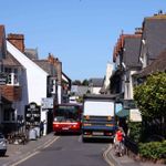
This time we’re talking all about mapping walking routes. Back in the Autumn, Emma Griffin from the Footways project joined Laura for a stroll around Bow in East London. Footways is a network of quiet and interesting streets for walking in London, with the aim of getting people out on the pavements and walking for transport.
Their aim is to make the pedestrian network the top priority when it’s often the lowest.
View Footways’ Google map layer: https://www.google.com/maps/d/u/0/viewer?mid=1djPyfTHyWyHfqVNNIqStpRbvXZ7yabk0&ll=51.51235318211866%2C-0.13645850981252927&z=14
Read Laura’s CityLab article on Footways: https://www.bloomberg.com/news/articles/2021-10-27/mapping-london-s-best-walking-streets
We hope you enjoy this episode of Streets Ahead, a podcast dedicated to the world of active travel, liveable streets and people-focused urban design.
We’re on Twitter and welcome your feedback on our episode: http://www.twitter.com/podstreetsahead
If you're reading this, please can you take 1 minute to give us a rating and write a review? It helps us more than you probably think.
Support Streets Ahead on PatreonHosted on Acast. See acast.com/privacy for more information.